Le relevé aérien architectural par drone est la solution la plus moderne pour documenter l'existant. Que ce soit pour la rénovation, la préservation du patrimoine ou l'inspection d'ouvrages d'art, nous sécurisons vos interventions :
Die architektonische Luftbildvermessung per Drohne ist die modernste Lösung zur Dokumentation des Bestands. Ob für Sanierungen, Denkmalschutz oder die Inspektion von Ingenieurbauwerken, wir machen Ihre Eingriffe sicherer:
Architectural aerial surveying by drone is the most modern solution for documenting existing structures. Whether for renovation, heritage preservation, or the inspection of engineering structures, we secure your interventions:
Architecturale luchtmeting per drone is de modernste oplossing voor het documenteren van bestaande structuren. Of het nu gaat om renovatie, behoud van erfgoed of de inspectie van kunstwerken, wij beveiligen uw interventies:
Nos restitutions 3D (Jumeaux numériques) sont directement exploitables par les architectes et intégrables dans les processus BIM (Building Information Modeling).
Unsere 3D-Rekonstruktionen (Digitale Zwillinge) sind für Architekten direkt nutzbar und in BIM-Prozesse (Building Information Modeling) integrierbar.
Our 3D reconstructions (Digital Twins) are directly usable by architects and can be integrated into BIM (Building Information Modeling) processes.
Onze 3D-reconstructies (Digitale Tweelingen) zijn direct bruikbaar door architecten en integreerbaar in BIM-processen (Building Information Modeling).

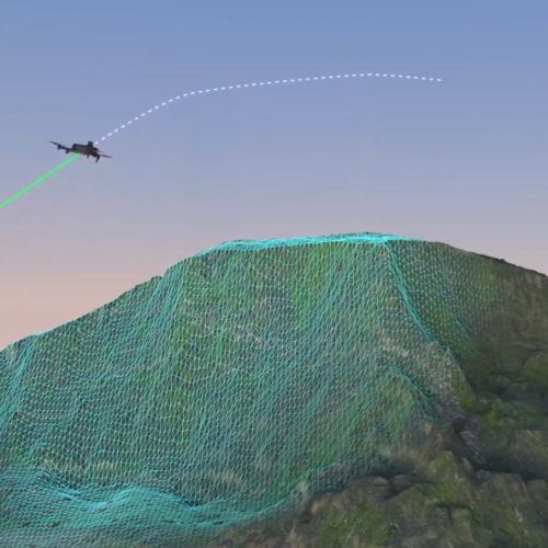
En combinant des centaines de clichés sous différents angles, nous recréons une copie numérique parfaite de vos bâtiments : le Jumeau Numérique.
Durch die Kombination hunderter Bilder aus verschiedenen Winkeln erstellen wir eine perfekte digitale Kopie Ihrer Gebäude: den Digitalen Zwilling.
By combining hundreds of photos from different angles, we recreate a perfect digital copy of your buildings: the Digital Twin.
Door honderden foto's vanuit verschillende hoeken te combineren, creëren we een perfecte digitale kopie van uw gebouwen: de Digitale Tweeling.
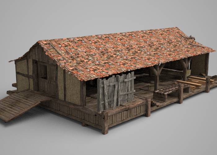
Nous générons des modèles maillés texturés (Textured Mesh) hautement réalistes, parfaits pour l'intégration paysagère de futurs projets, les visites virtuelles ou la documentation historique.
Wir generieren hochrealistische texturierte Gittermodelle (Textured Mesh), die sich perfekt für die landschaftliche Integration zukünftiger Projekte, virtuelle Rundgänge oder historische Dokumentationen eignen.
We generate highly realistic textured mesh models, perfect for the landscape integration of future projects, virtual tours, or historical documentation.
We genereren zeer realistische getextureerde mesh-modellen, perfect voor de landschappelijke integratie van toekomstige projecten, virtuele rondleidingen of historische documentatie.
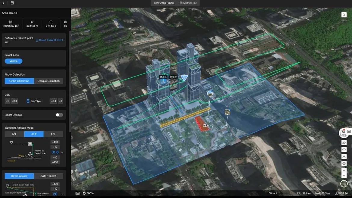
Nous créons des orthophotos détaillées et à l'échelle (débarrassées des perspectives déformantes) pour le relevé précis des façades ou l'état des toitures.
Wir erstellen detaillierte und maßstabsgetreue Orthophotos (frei von perspektivischen Verzerrungen) für die präzise Erfassung von Fassaden oder den Zustand von Dächern.
We create detailed, to-scale orthophotos (free from distorting perspectives) for precise facade surveys or roof condition assessments.
Wij creëren gedetailleerde, op schaal gemaakte orthofoto's (vrij van vervormende perspectieven) voor nauwkeurige gevelopmetingen of de beoordeling van de staat van daken.
C'est la base idéale pour redessiner des plans d'élévation sur AutoCAD, planifier des rénovations énergétiques ou réaliser des métrés précis sans monter sur le bâtiment.
Dies ist die ideale Grundlage, um Ansichtspläne in AutoCAD nachzuzeichnen, energetische Sanierungen zu planen oder präzise Aufmaße zu erstellen, ohne das Gebäude betreten zu müssen.
This is the ideal basis for redrawing elevation plans in AutoCAD, planning energy renovations, or creating precise measurements without stepping onto the building.
Dit is de ideale basis voor het hertekenen van gevelplannen in AutoCAD, het plannen van energetische renovaties of het maken van nauwkeurige metingen zonder het gebouw te betreden.
Nos capteurs très haute résolution permettent d'identifier les pathologies du bâtiment : fissures, défauts d'étanchéité, ou détérioration des matériaux.
Unsere hochauflösenden Sensoren ermöglichen die Identifizierung von Bauschäden: Risse, Undichtigkeiten oder Materialverschleiß.
Our ultra-high-resolution sensors allow us to identify building pathologies: cracks, waterproofing defects, or material deterioration.
Onze sensoren met ultrahoge resolutie stellen ons in staat gebouwpathologieën te identificeren: scheuren, waterdichtheidsgebreken of materiaalverslechtering.
Accouplé à nos logiciels, vous pouvez annoter directement le modèle 3D pour un suivi collaboratif des désordres structurels avec les bureaux de contrôle.
In Verbindung mit unserer Software können Sie das 3D-Modell direkt mit Anmerkungen versehen, um strukturelle Mängel gemeinsam mit den Prüfbüros zu verfolgen.
Coupled with our software, you can directly annotate the 3D model for collaborative tracking of structural disorders with control offices.
Gekoppeld aan onze software kunt u het 3D-model direct annoteren voor collaboratieve opvolging van structurele defecten met controlebureaus.